
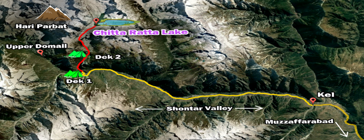
Chitta Katha Lake sits at 4100 meters above the sea level or 13550 feet. It is ringed by the Hari Parbat and some other snow-capped jagged mountains. The trek is noted for its beauty amidst a varied landscape, water courses and towering waterfalls. It is in the Shontar Valley which is an off shoot of the Upper Neelum Valley in AJK. The Valley extends into the Astor district of Gilgit Baltistan by negotiating the Shontar Pass.
We had desired to trek in the Neelum Valley and Chitta Katha Lake trek was suggested by Mr Nawaz of AJK Tourism Department. I am grateful to those who supported us, Mr Zaheer of Kel (03558111619), the guides, trekking camps’ staff, and the jeep driver. The trekkers included Asad, Imtiaz, and Adnan. Spotting a break in the monsoons, we left Islamabad on 11 August to overnight at Muzaffarabad. We left early morning for Kel via the picturesque Neelum Valley.
We reached Kel by mid-day and decided to leave for the trek’s Base Camp or Dek 1, which is close to Upper Domail in the Shontar Valley. We travelled in a hired jeep over 20 odd kilometers along the Shontar River on a largely stony road to reach Dek 1. It is named after a village that one passes through early in the trek.
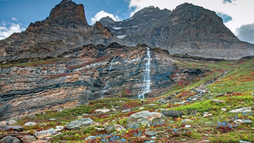
| Waterfall and Hari Parbat mountain enroute to the Lake |
After leaving the unrequired baggage we started the trek for Dek 2 (camp which is the kick-off point for trek to the Lake). It is an upstream trek along a water channel which narrows down to a gorge as one goes up. After climbing a near vertical face, we entered an open valley where the gradient eases. In about two hours and fifteen minutes we reached Dek 2 to stay the night. A group of young trekkers from Lahore were there and others joined late at night. Early on 13 August we left for the Lake.
Having negotiated another gorge along the same water channel, we entered an open valley which merges into raised mountains, some with dark chiselled faces with a beautiful water fall cascading next to the Hari Parbat Mountain. The Valley has wetland characteristics with marmots plunging into their holes as we approached. Nature was at its splendid best with multi-coloured wildflowers in full bloom.
The incline grew sharper as we went along. After gaining a certain height we negotiated a steep climb next to the waterfall. It took us to an open elevated plateau with number of crest lines. Asad and Adnan reached the Lake in about three hours, and I followed them twenty minutes later. It is a bit of a hidden lake as you can only spot it from very close. The snow-covered mountains stood on the far end and the Hari Parbat massif towards the left while facing the Lake.
We termed it as the ‘Independence Day trek’ and pictured ourselves on the Lake with the national flags. Group of young men from AJK joined us carrying the State flag. It was a bit festive, and we then started our journey back. It took us about the same time to return to Dek 2 and Dek 1 as negotiating the stony patches and sharp descends consumed much time. We returned to Kel late in the evening.

| At the Chitta Katha Lake. Kamran, Asad & Adnan (L to R) |
As we had no prior knowledge of the trek while planning it, so we accessed its video accounts. Not much is available in terms of written accounts. Most narrations give an exaggerated version of the difficulty faced, distances and the timings with respect to the Chitta Katha Lake trek. Yes, it is challenging and requires a certain level of physical fitness, but it is doable in two days with an overnight. Its aesthetics make it worth it.
The trekking venues that we visited over the past two years are in the remote regions. The people there are poor with marginal access to social services. In some treks, including this one, we took some general use medicines for distribution among the locals and those who assisted us during the trek. We would certainly encourage adoption of such practices and it could be medicines or some other form of assistance.
Finally, the sore point about trashing with utter abandon in these pristine locations. It was painful to see waste littered all along the trail right till the Lake. Correct waste disposal is an attribute of the civilised people, but we sadly have much distance to cover in adopting such practices. Yes, the government must launch an awareness campaign, work with the local tour operators and communities to better manage the waste. But primarily it is the INDIVIDUAL RESPONSIBILITY NOT TO TRASH.
On our way back we decided to visit the Noori Top located between the Neelum and Naran valleys. We got on to the road from Sharda in the Neelum Valley. The first twelve kilometers is paved but the incline is stiff amid heavy forests. A water channel cascades down towards the Neelum River. Glacier leftovers straddle the channel, and their sizes increase as you gain height.
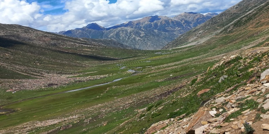
| An open Valley towards Jalkhad while traveling from the Noori Top |
The jeep track gradually ascends to the Noori Top at 12,956 feet. Close to the Top the track is in bad repair with sharp turns and stiff gradient. The valley towards the Naran side is relatively open and the track descends gradually. We negotiated a fresh slide thanks to Asad’s driving skills. We reached Jalkhad in the Naran Valley by mid-day and later Islamabad by the evening. To conclude, poor maintenance of the Noori Top trek does not render it safe as a logistics or even a touristic route.
Summary:
| Access | Logistics | Treks | Safety | Cost | Aesthetics |
| Jeep to be hired plus of Kel | Provided on-site | Moderate to Difficult | Safe. Guide is recommended. | Approx Rs 18000 per person to cover jeep hire, guides, overnight stay & fuel | Very Pleasing |