


Village Narar is located on an extended plateau around 6000 feet above the sea level with a sharp escarpment with prominent rocks and steep drops. Located in Tehsil Kahuta, about 70 kilometers from Islamabad, it is a tourist attraction with a waterfall and a vintage Rest House. It overlooks River Jhelum and Panjpeer Ziarat is located on the northern edge of the Plateau and therefore, the appellation Panjpeer Rocks. A tourism highway is being constructed that will link it with the wider scenic region.

Trek to Panjpeer Rocks
Our trek commenced along the Kashmir face, close to the Azad Pattan bridge located about 27 kilometres upstream from the Karot Dam. It entails a climb of about 4300 feet or nearly 1300 meters. Most the route is ill-defined as it is less frequented due to the improved road network in the region. Therefore, the need to hire a local guide.
We left Islamabad early on 11 February and were joined by Air Commodore (retired) Tufail Satti. He is brother of my Army Course mate Brigadier (retired) Javed Satti, a local, who has contributed very impressively to promote education and to save forests of the region. He and Air Commodore Tufail were kind to facilitate our trek and attended to the associated logistics for which we are grateful. Besides the Air Commodore, the trekkers included myself, Asad, Amin and Adnan.
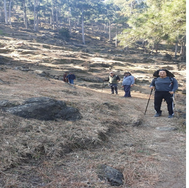
We kicked off from close to the Azad Pattan bridge and trekked along a water channel on an ill-defined track which was steep at places. It led to a relatively open patch after about two hours of climb with some isolated houses. A local person guided us to a comparatively gradual ridgeline approach leading to the Panjpeer Rocks as opposed to steeper climb along the route that we were following. As we climbed the ascending ridgelines, the Rocks started to become visible. On our back or towards southeast, one could see mountains of districts Rawalakot and Palandari in AJK.

| Panjpeer Escarpment as seen during the Trek |
We traversed an open patch where a local fair, we were told, is held. The track started to become better defined and it followed the water flow channels at places with the slippery moss which had to be carefully negotiated. We approached the Panjpeer Rocks from the southern edge and they extend westwards in an expansive sloping plateau. It took us nearly four and a quarter hour to complete the trek. The view from the Rocks was fascinating on a pleasant day with the snow-capped Pir Punjal Range defining the Kashmir skyline. After a well-deserved cup of tea, we headed back by road on our journey back.
How do we sum up the trek. It is easily approachable from Islamabad and is a one-day affair that curtails the logistics. One can term it as a moderate-to-difficult winter trek that requires local guidance. We were told that there are numerous trekking routes leading to the Panjpeer Rocks. We chose a scenic, somewhat challenging but a very enjoyable one. The region has a vast untapped tourism potential.